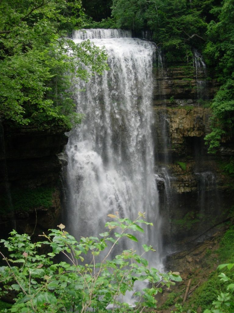
Virgin Falls is 1,157-acre natural area located in White County. The natural area is named for Virgin Falls, which is formed by an underground stream that emerges from a cave, then drops over a 110-foot high cliff before disappearing into another cave at the bottom of the sink.
The area is noted for its unique geological features and several (additional) other waterfalls including Big Laurel, Sheep Cave Falls, and Big Branch Falls. There are several notable caves in the area, including the cave above Virgin Falls, where the stream itself that forms the falls issues. Due to white nose syndrome, all caves on the area are closed to recreational use. The sinkholes at Virgin Falls, such as Virgin Falls Sink and Sheep Cave Sink, are characteristic of karst features found on the Cumberland Plateau.
The Caney Fork River and its tributaries drain the area and contribute to the formation of the gorge. The Martha’s Pretty Point provides a dramatic view of Scott’s Gulf and the Caney Fork River 900 ft below.
A Note of Caution and Awareness!
The hike into Virgin Falls, which will total around 9 miles going in and out, should be considered a strenuous hike. The trail descends around 900 foot in elevation along a path that in many areas is rocky with uneven footing. Please allow 5 to 9 hours for the hike. And it is recommended to start the hike early in the day, in order to give yourself plenty of daylight. Know your physical ability! And be prepared with water, food, and clothing for the season. All hikers should let a family member or a friend know of their hiking plans, and expected time back home. At 1.5 miles there is a cable crossing at Big Laurel Creek: if the creek is flooding, please do not attempt to cross! Overall, please check the forecast before heading out on this hike.
Hiking to Virgin Falls and back to the parking area is a five to eight hour hike depending on your pace and whether you hike to the Caney Fork Overlook and/or the Caney Fork River. The trail leaving the parking area meanders down to the Big Branch of the Big Laurel Creek through an upland oak-hickory/chestnut oak hardwood forest crisscrossing a fern dominated upland drainage. Upon descending into the gorge the vegetation changes to hemlock and mixed mesophytic forest which includes maples, oaks, tulip poplar, hickories, buckeye, basswood, cherry, yellow birch, sycamore, and many more species. Mountain laurel, magnolia and several ericaceous shrubs (such as various wild blueberries) are common along the trail. The trails pass by small rockhouses, boulder fields, sinks, caves, and waterfalls on route to Virgin Falls where the trail ends. The distance to Virgin Falls is four miles one way. There are designated camping sites off the trail (see map). There is no camping allowed above Virgin Falls. Virgin Falls State Natural Area is located in the Scott’s Gulf area, and adjacent to the Bridgestone/Firestone Centennial Wilderness, which also has some great trails. The Virgin Falls area was originally set aside in 1973 as a Pocket Wilderness by the Bowater Pulp and Paper Corporation. It was purchased from a private landowner by the State in 2012, partially with a grant from the U.S. Fish and Wildlife Service. The deep gorges, rich vegetation, sparkling waterfalls, and streams make this area a favorite hiking and backpacking destination. All natural and cultural features are protected. Please be sure to respect the resources, and to take out all waste brought in. If camping, please leave your campsite in as good as, or better shape than you found it.
Address for Virgin Falls Trailhead: 2080 Scotts Gulf Road, Sparta, TN 38583